This section contains additional airport specific information on runway surface condition assessment and reporting, complementing the information contained in AIP AD 1.2.
|
1
|
Ilma-alusten seisontapaikkakyltit,
rullausopasteet |
On
Ks. Visuaalisen telakoitumisen opastinjärjestelmä alla Yes See Visual docking / parking guidance system of aircraft stands below |
|
Use of aircraft stand ID signs, TWY guide lines
|
||
|
2
|
RWY / TWY merkinnät ja valaistus
|
RWY: ID, THR, TDZ, RCL, reunaviivat, tähtäyspistemerkinnät
RWY: ID, THR, TDZ, RCL, side stripes, aiming point markings TWY: CL, kiitotieodotuspaikat TWY: CL, runway-holding positions RWY / TWY LGT: REF EFOU AD 2.14, EFOU AD 2.15 |
|
RWY / TWY markings and LGT
|
||
|
3
|
Pysäytysvalorivit
|
NIL
|
|
Stop bars
|
||
|
4
|
Muut kiitotien suojaustoimenpiteet
|
NIL
|
|
Other runway protection measures
|
||
|
5
|
RMK
|
Kiitotien varoitusvalot (FLG Y) rullausteillä A, B, C, D, E, M ja P.
RWY guard LGT (FLG Y) on taxiways A, B, C, D, E, M and P. |
Visual Nose-in Docking Guidance System for stands 13, 14, 15 and 16 (SAFEDOCK)
REF EFOU AD 2.20, Ilma-aluksen seisontapaikat / ACFT stands
Instructions
REF EFOU AD 2.20, Ilma-aluksen seisontapaikat / ACFT stands
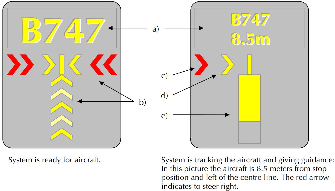
- Display indicating: Aircraft type, Distance to stop, "STOP", "OK", "TOO FAR", "WAIT", "SLOW", "ID/FAIL".
- The floating arrows indicating that the system is ready for aircraft to start docking procedure.
- Red arrow indicating the direction to turn.
- Yellow arrow shows position in relation to the centre line.
- Closing rate bar.
Instructions
- Follow taxi-in line guidance.
- Check correct aircraft type is displayed.
- The floating arrows indicate that the system is ready for aircraft to start docking procedure. When the system is tracking the aircraft, the floating arrows are replaced by the closing rate bar.
- The pilot must not proceed beyond the bridge, unless the floating arrows have been superseded by the closing rate bar.
- MAX approach speed is 11 KM/H (3 M/SEC). If exceeded, display indicates "SLOW".
- During bad weather conditions the visibility for the docking system can be reduced. In that case the display will disable the floating arrows and display aircraft type and “SLOW”. As soon as the system detects the approaching aircraft, the closing rate bar will appear.
- “STOP/ID FAIL”: Aircraft type verification is failed. Interrupt taxiing and contact OULU TOWER 124.400 MHZ.
- Fully yellow coloured closing rate bar indicates that aircraft position is at least 15 M to stop position. When distance is 14.5 M to stop position the yellow coloured closing rate indication starts to shorten from the bottom, one row indicates about 0.5 meters.
- When stop position is reached, display indicates "STOP". Correct parking is indicated as "OK".
- If aircraft overshoots the limit for correct parking, display indicates "TOO FAR".
- “WAIT”: Some object is blocking the view, aircraft is lost during tracking or system is not ready. Wait until the message is superseded by closing rate indicator and aircraft type.
- Display automatically shuts down after parking.
- In case of malfunction in the docking guidance system interrupt taxiing and contact OULU TOWER 124.400 MHZ.
Area 2 electronic obstacle data, as specified in ICAO Annex 15, is not available.
Electronic list containing man-made obstacles, that penetrate ICAO Annex 14 (national aviation regulation AGA M3-6) obstacle limitation surfaces and are over 3 M AGL, is available in csv format.
Csv files are available at:
These files do not comply with all the ICAO Annex 15 specifications for electronic obstacle data. The data users shall therefore carefully assess the set of available data so as to determine whether the product is adapted to their intended use.
|
1
|
Vastuussa oleva lentosääkeskus
|
LEN Pohjoinen / LEN North
|
|
Associated MET Office
|
||
|
2
|
Palveluajat
Toissijainen lentosääkeskus |
H24
NIL |
|
Hours of service
MET Office outside hours |
||
|
3
|
TAF-ennusteet laativa lentosääkeskus
Voimassaoloaika Julkaisutiheys |
LEN Pohjoinen / LEN North
24 HR 3 HR |
|
Office responsible for TAF preparation
Period of validity Interval of issuance |
||
|
4
|
TREND-ennusteen saatavuus
Julkaisutiheys |
NIL
|
|
Availability of TREND forecast
Interval of issuance |
||
|
5
|
Säätuotteiden jakelu ja sääneuvonta
|
www.ilmailusaa.fi (self-briefing)
TEL +358 600 9 3808 Meteorologi / Forecaster - maksullinen palvelu / charged service |
|
Briefing and consultation provided
|
||
|
6
|
Sääasiakirjat
Käytettävät kielet |
Asetuksen (EU) 2017/373 edellyttämät sääkartat ja -sanomat
Charts and forms according to (EU) 2017/373 requirements EN |
|
Flight documentation
Language(s) used |
||
|
7
|
Jakelussa ja sääneuvonnassa käytettävät muut kartat ja tiedot
|
Fennoskandian alueelta saatavilla myös muuta havainto- ja ennustetietoa
Other observations and forecasts available for Fennoscandian area www.ilmailusaa.fi |
|
Charts and other information available for briefing and consultation
|
||
|
8
|
Täydentävä laitteisto lisätiedon tuottamiseksi
|
NIL
|
|
Supplementary equipment available for providing information
|
||
|
9
|
Palveltavat ATS-yksiköt
|
OULU ATS
|
|
ATS units provided with information
|
||
|
10
|
Lisätiedot (rajoitukset yms.)
|
NIL
|
|
Additional information (limitations of service etc.)
|
|
RWY ID
|
TRUE BRG
|
DMN RWY M
|
PCN and SFC of RWY and SWY
|
THR COORD
RWY end COORD THR GUND |
THR ELEV
TDZ ELEV |
|---|---|---|---|---|---|
|
1
|
2
|
3
|
4
|
5
|
6
|
|
12
|
120.98
|
2501 x 60
|
PCN 100/F/A/W/T
ASPH SWY: NIL |
645609.01N 0251954.82E
645527.41N 0252238.01E GUND: 58.0 FT |
THR: 47.9 FT
TDZ: 47.3 FT |
|
30
|
301.02
|
2501 x 60
|
PCN 100/F/A/W/T
ASPH SWY: NIL |
645527.41N 0252238.01E
645609.01N 0251954.82E GUND: 58.0 FT |
THR: 34.0 FT
TDZ: 45.3 FT |
Note 1: The take-off positions, on which the reduced declared distances are based, are shown on the AOC chart concerned indicated with "REDUCED DECLARED DISTANCES CALCULATION POINT" symbols.
Note 2: The take-off positions on the runway are not marked by painted markings or sign boards.
|
RWY ID
|
APCH LGT
type LEN INTST |
THR LGT
colour WBAR |
VASIS
(MEHT) PAPI |
TDZ LGT
LEN |
RCL LGT LEN
spacing colour INTST |
REDL
LEN spacing colour INTST |
RENL
colour WBAR |
SWY LGT
LEN colour |
RMK
|
|---|---|---|---|---|---|---|---|---|---|
|
1
|
2
|
3
|
4
|
5
|
6
|
7
|
8
|
9
|
10
|
|
12
|
CAT II / III
900 M W LIH R LIL |
G
LIH |
PAPI
Left side/3° (55 FT) |
W
LIH 900 M |
W
LIH 1600 M Alternate W LIH / R LIH 600 M, R LIH last 300 M, CAT II, longitudinal spacing 15 M |
W
LIH YCZ 600 M |
R
LIH |
NIL
|
NIL
|
|
30
|
SIMPLE
780 M W LIH R LIL |
G
LIH |
PAPI
Left side/3.5° (63 FT) |
NIL
|
W
LIH 1600 M Alternate W LIH / R LIH 600 M, R LIH last 300 M, CAT II, longitudinal spacing 15 M |
W
LIH YCZ 600 M |
R
LIH |
NIL
|
NIL
|
|
1
|
ABN / IBN sijainti, ominaistiedot ja
toiminta-ajat |
|
|
ABN / IBN location, characteristics and hours of operation
|
||
|
2
|
LDI sijainti ja valaistus
WDI sijainti ja valaistus |
LDI: NIL
WDI: COORD: 645548N 0252151E, LGTD |
|
LDI location and LGT
WDI location and LGT |
||
|
3
|
TWY reuna- ja keskilinjavalot
|
|
|
TWY edge and centre line lighting
|
||
|
4
|
Varavoima-asema
Vaihtoaika |
AVBL
13 SEC / 1 SEC (CAT II) |
|
Secondary power supply / switch-over time
|
||
|
5
|
RMK
|
NIL
|
|
Designation and lateral limits
|
Vertical limits
|
Airspace classification
|
ATS unit call sign Language(s)
|
Transition altitude
|
Hours of
applicability |
RMK
|
|---|---|---|---|---|---|---|
|
1
|
2
|
3
|
4
|
5
|
6
|
7
|
|
EFOU CTR
Area bounded by lines joining points 650810N 0250649E - 650001N 0253854E - 644952N 0254449E - 644324N 0253536E - 645519N 0244846E to point of origin. |
D
|
OULUN TORNI
OULU TOWER FI, EN |
5000 FT MSL
|
NOTAM
|
RMZ H24
|
|
SER
|
Call Sign
|
FREQ
|
HR UTC
|
SATVOICE
|
Logon address
|
RMK
|
|---|---|---|---|---|---|---|
|
1
|
2
|
3
|
4
|
5
|
6
|
7
|
|
APP
|
OULUN TUTKA
OULU RADAR |
118.150 MHZ
|
HO
|
NIL
|
NIL
|
NIL
|
|
119.700 MHZ
|
||||||
|
121.500 MHZ
|
||||||
|
TWR
|
OULUN TORNI
OULU TOWER |
124.400 MHZ
|
NOTAM
|
NIL
|
NIL
|
NIL
|
|
119.700 MHZ
|
||||||
|
121.500 MHZ
|
||||||
|
ATIS
|
-
|
135.450 MHZ
|
H24
|
NIL
|
NIL
|
EN
D-ATIS REF AIP, GEN 3.4, kohta 3.3.4. EN D-ATIS REF AIP, GEN 3.4, para 3.3.4 . |
Note: Outside the operational hours of ATS the ATIS broadcast is not monitored and may therefore be invalid.
|
Type of aid
MAG VAR CAT of ILS / MLS DECL |
ID
|
FREQ
CH |
HR UTC
|
PSN
|
DME
ELEV FT |
Service
volume radius |
RMK
|
|---|---|---|---|---|---|---|---|
|
1
|
2
|
3
|
4
|
5
|
6
|
7
|
8
|
|
LOC 12
ILS CAT II (11° E 2020) |
OU
|
109.500 MHZ
|
H24
|
645522.07N
0252258.94E |
NIL
|
NIL
|
NIL
|
|
GP 12
ILS CAT II |
OU
|
332.600 MHZ
|
H24
|
645600.65N
0252009.50E |
NIL
|
NIL
|
Angle: 3.0°
|
|
DME 12
ILS CAT II |
OU
|
109.500 MHZ
(CH32X) |
H24
|
645600.65N
0252009.50E |
100 FT
|
NIL
|
NIL
|
|
DVOR/DME
(11° E 2020) (DECL 11°E) |
OUK
|
113.300 MHZ
(CH80X) |
H24
|
645553.59N
0252133.42E |
66 FT
|
NIL
|
NIL
|
Note: Outside the operational hours of ATS the signals of radio navigation and landing aids are not monitored and may therefore be invalid.
Take-offs from the specified intersection of runway / taxiways intersections can be performed upon the pilot-in-command's request the traffic situation permitting 0500-2000 UTC (0400-1900 UTC).
Declared distances, see para AD 2.13.
If necessary, the number of aircraft cleared to fly in the aerodrome traffic circuit is restricted by ATC. The number of aircraft is determined by e.g. weather conditions, maintenance works or other traffic.
OULU TOWER 124.400 MHZ
4.2.1. Taxiing on the apron is always subject to instructions.
Note:
The ATC issues clearances for taxiing only within the ATC Service Boundary presented on the aerodrome chart (ADC). For taxiing on the apron ATC does not issue clearances but taxi instructions. See also AIP, AD 1.1, para 7.2.
4.2.2. When taxiing on the apron the aircraft shall follow the yellow taxiing guide lines. No deviations or short cuts are permitted except under the guidance of a follow-me car or after special instructions given by the appropriate ATC unit.
4.3.1. Start-up and push back clearance
Contact Oulu TWR for start-up and push back clearance. The stand of the aircraft shall be stated in the initial contact with the ATC unit.
4.3.2. Taxi clearance and instructions
Taxi instructions and clearance given by ATC shall be followed when taxiing. Unless otherwise instructed the aircraft shall use the shortest possible way to the taxiway parallel to the runway to continue further to the clearance limit given by the ATC.
The use of fuel canisters, and the like, for refuelling is prohibited in the airport area unless the airport has published a written local procedure.
|
Name
|
APN
|
COORD
|
ELEV
|
PCN
|
VDGS
|
SFC
|
RMK
|
|---|---|---|---|---|---|---|---|
|
1
|
2
|
3
|
4
|
5
|
6
|
7
|
8
|
|
5
|
APN 2
|
645548.06N 0252204.81E
|
42 FT
|
80/F/A/W/T
|
NIL
|
ASPH
|
NIL
|
|
6
|
APN 2
|
645547.40N 0252202.03E
|
43 FT
|
80/F/A/W/T
|
NIL
|
ASPH
|
NIL
|
|
7A
|
APN 2
|
645546.69N 0252159.17E
|
43 FT
|
80/F/A/W/T
|
NIL
|
ASPH
|
NIL
|
|
7B
|
APN 2
|
645546.07N 0252201.58E
|
44 FT
|
80/F/A/W/T
|
NIL
|
ASPH
|
NIL
|
|
8
|
APN 2
|
645545.86N 0252201.25E
|
44 FT
|
80/F/A/W/T
|
NIL
|
ASPH
|
NIL
|
|
9
|
APN 1
|
645544.72N 0252209.63E
|
45 FT
|
80/F/B/W/T
|
NIL
|
ASPH
|
NIL
|
|
10
|
APN 1
|
645543.66N 0252213.80E
|
44 FT
|
80/F/B/W/T
|
NIL
|
ASPH
|
NIL
|
|
11
|
APN 1
|
645542.59N 0252217.96E
|
43 FT
|
80/F/B/W/T
|
NIL
|
ASPH
|
NIL
|
|
12A
|
APN 1
|
645541.36N 0252221.43E
|
42 FT
|
80/F/B/W/T
|
NIL
|
ASPH
|
NIL
|
|
12B
|
APN 1
|
645541.50N 0252222.02E
|
42 FT
|
80/F/B/W/T
|
NIL
|
ASPH
|
NIL
|
|
13
|
APN 1
|
645541.03N 0252225.06E
|
42 FT
|
80/R/B/W/T
|
NIL
|
CONC
|
NIL
|
|
13B
|
APN 1
|
645540.51N 0252224.80E
|
41 FT
|
80/R/B/W/T
|
NIL
|
CONC
|
NIL
|
|
14
|
APN 1
|
645540.35N 0252228.81E
|
41 FT
|
80/R/B/W/T
|
NIL
|
CONC
|
NIL
|
|
15
|
APN 1
|
645539.52N 0252231.96E
|
40 FT
|
80/R/B/W/T
|
NIL
|
CONC
|
NIL
|
|
15B
|
APN 1
|
645538.98N 0252231.44E
|
39 FT
|
80/R/B/W/T
|
NIL
|
CONC
|
NIL
|
|
16
|
APN 1
|
645538.80N 0252236.55E
|
39 FT
|
80/R/B/W/T
|
NIL
|
CONC
|
NIL
|
Note: REF ENR 1.5 , para 4.
Civil aviation must use runway 12 as the primary landing runway at night 2000-0500 UTC (1900-0400 UTC) and runway 30 as the primary take-off runway, unless otherwise dictated by air traffic safety. These regulations do not apply to flying over the aerodrome traffic pattern during general aviation training.
IFR and VFR training flights shall be accomplished during 0500-2000 UTC (0400-1900 UTC). Between the beginning of September and the end of April night-time training shall be accomplished MON-THU by 2300 UTC (2200 UTC), excluding take-off or landing of individual en-route flight.
Note 1: The general departure, arrival and holding procedures are described in section ENR 1.5.
Note 2:
The base of medical helicopter is located at the airport. In case of status flight (medical/HOSP) it has a priority to other traffic. The call sign of the medical helicopter is “Finnhems”.
Note: See also section AD 1.
1.1.1. Low Visibility Procedures for Take-off (LVPTO)
Runways 12 and 30 are approved for Low Visibility Procedures for Take-offs when the RVR value is 550 M or less.
1.1.2. Low Visibility Procedures for approaches and landing
RWY 12 is approved for CAT II approaches and is available for Category II approaches by an operator who has been authorized by its controlling state and a copy of such authorization is carried on board the aircraft or has been delivered to the Finnish Transport Safety Agency.
Low Visibility Procedures for all air traffic will become effective when the TDZ RVR value of the runway in use decreases to 550 M.
The application of the Low Visibility Procedures will be informed to the pilots by ATIS or ATC.
ATC will always give the Touch Down Zone RVR.
Midpoint and Stop End RVR values will be given only if they are:
1.4.1. Departing aircraft
Aircraft using RWY 12/30 for departure are not allowed to start taxi without prior permission of ATC.
1.4.2. Arriving aircraft
Pilots shall report “RUNWAY VACATED AND ON APRON" only when aircraft has arrived on apron.
Radar vectored aircraft will be vectored to intercept ILS localizer so, that the ILS localizer is established not less than 10 NM before the touchdown.
Traffic may be subject to flow restrictions during Low Visibility Procedures.
In case the aerodrome is unable to comply with Low Visibility Procedures the pilots are informed either by ATIS or ATC: "AIRPORT UNABLE TO COMPLY WITH LOW VISIBILITY PROCEDURES".
|
EU-ilmailumääräys Aerodrome rules |
Otsikko |
Title |
Poikkeaman kuvaus |
Description of the deviation |
|---|---|---|---|---|
|
CS ADR-DSN.J.475 |
Ei-tarkkuuslähestymiskiitotiet |
Non-precision approach runways |
Esterajoituspintojen ylittäviä esteitä |
Obstacles exceeding obstacle limitation surfaces |
|
CS ADR-DSN.J.480 |
Tarkkuuslähestymiskiitotiet |
Precision approach runways |
Esterajoituspintojen ylittäviä esteitä |
Obstacles exceeding obstacle limitation surfaces |
|
CS ADR-DSN.T.915 |
Esteet liikennealueella |
Siting of equipment and installations on operational areas |
Kiitoalueella on kiinteät verkko- ja vaijeripysäytysjärjestelmät |
Fixed arresting nets and cables on runway strip |
|
Charts
|
Pages
|
|---|---|
|
ADC
|

|
|
ADC RUNWAY AND TAXIWAY MARKINGS
|
|
|
AOC RWY 12/30
|
|
|
PATC RWY 12
|
|
|
ATC SMAC
|
|
|
RNAV SID RWY 12
|
|
|
RNAV SID RWY 30
|
|
|
OMNIDIRECTIONAL DEPARTURES
|
|
|
RNAV STAR RWY 12
|
|
|
RNAV STAR RWY 30
|
|
|
NON-RNAV INA RWY 12
|
|
|
NON-RNAV INA RWY 30
|
|
|
ILS Z or LOC Z RWY 12
|
|
|
ILS Z RWY 12 CAT II
|
|
|
ILS Y or LOC Y RWY 12
|
|
|
ILS Y RWY 12 CAT II
|
|
|
RNP RWY 12
|
|
|
VOR RWY 12
|
|
|
RNP RWY 30
|
|
|
VOR RWY 30
|
|
|
VAC
|
|
|
LDG
|
|
|
WAYPOINTS AND FIXES
|
|
|
FAS DATA BLOCK
|
|
|
PRD INDEX
|
|
No penetrations