Primary international aerodrome (REF AD 1.4)
This section contains additional airport specific information on runway surface condition assessment and reporting, complementing the information contained in AIP AD 1.2.
|
1
|
Ilma-alusten seisontapaikkakyltit,
rullausopasteet |
On
Ks. Visuaalisen telakoitumisen opastinjärjestelmä alla Yes See Visual docking / parking guidance system of aircraft stands below REF EFRO AD 2.5 - 1 (APDC) |
|
Use of aircraft stand ID signs, TWY guide lines
|
||
|
2
|
RWY / TWY merkinnät ja valaistus
|
RWY: ID, THR, TDZ, RCL, reunaviivat, tähtäyspistemerkinnät, osastolentoonlähtöviivat (vain sotilaskäyttöön)
TWY: CL, kiitotieodotuspaikat RWY: ID, THR, TDZ, RCL, side stripes, aiming point markings, formation departure lines (only for military operations) TWY: CL, runway-holding positions RWY / TWY LGT: REF EFRO AD 2.14, EFRO AD 2.15 |
|
RWY / TWY markings and LGT
|
||
|
3
|
Pysäytysvalorivit
|
NIL
|
|
Stop bars
|
||
|
4
|
Muut kiitotien suojaustoimenpiteet
|
NIL
|
|
Other runway protection measures
|
||
|
5
|
RMK
|
REF EFRO AD 2.4 - 1 (ADC)
Kiitotien varoitusvalot (FLG Y) rullausteillä A, B, C, D, E, G, H, J, L, N Sulkuvalot rullausteillä B, C, D, G, H, J, L, M, N RWY guard LGT (FLG Y) on taxiways A, B, C, D, E, G, H, J, L, N Closure lights on taxiways B, C, D, G, H, J, L, M, N |
REF EFRO AD 2.20, Ilma-aluksen seisontapaikat / ACFT stands
Visual Nose-in Guidance system for stands 7 and 8
Instructions
Visual Nose-in Guidance system for stands 7 and 8
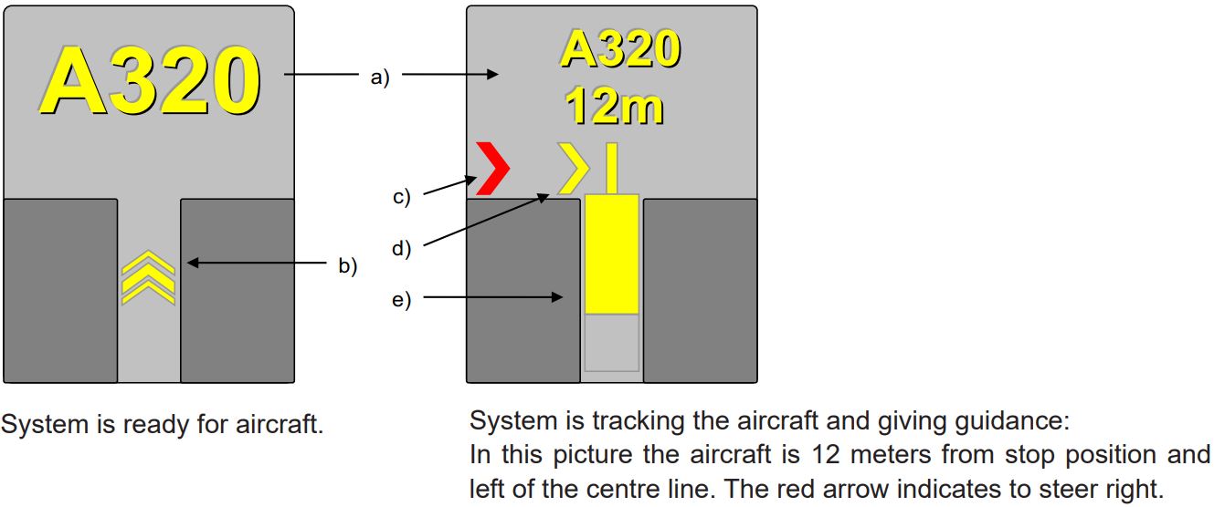
- Display indicating: Aircraft type, Distance to stop, "STOP", "OK", "TOO FAR", "WAIT", "SLOW", "ID/FAIL".
- The floating arrows indicating that the system is ready for aircraft to start docking procedure.
- Red arrow indicating the direction to turn.
- Yellow arrow shows position in relation to the centre line.
- Closing rate bar.
Instructions
- Follow taxi-in line guidance.
- Check correct aircraft type is displayed.
- The floating arrows indicate that the system is ready for aircraft to start docking procedure. When the system is tracking the aircraft, the floating arrows are replaced by the closing rate bar.
- The pilot must not proceed beyond the bridge, unless the floating arrows have been superseded by the closing rate bar.
- During bad weather conditions the visibility for the docking system can be reduced. In that case the display will disable the floating arrows and display aircraft type and “SLOW”. As soon as the system detects the approaching aircraft, the closing rate bar will appear.
- “STOP/ID FAIL”: Aircraft type verification is failed. Interrupt taxiing and contact ROVANIEMI TOWER 119.700 MHZ.
- When stop position is reached, display indicates "STOP". Correct parking is indicated as "OK".
- If aircraft overshoots the limit for correct parking, display indicates "TOO FAR".
- “WAIT”: Some object is blocking the view, aircraft is lost during tracking or system is not ready. Wait until the message is superseded by closing rate indicator and aircraft type.
- Display automatically shuts down after parking.
- In case of malfunction in the docking guidance system interrupt taxiing and contact ROVANIEMI TOWER 118.700 MHZ.
Area 2 electronic obstacle data, as specified in ICAO Annex 15, is not available.
Electronic list containing man-made obstacles, that penetrate ICAO Annex 14 (national aviation regulation AGA M3-6) obstacle limitation surfaces and are over 3 M AGL, is available in csv format.
Csv files are available at:
These files do not comply with all the ICAO Annex 15 specifications for electronic obstacle data. The data users shall therefore carefully assess the set of available data so as to determine whether the product is adapted to their intended use.
|
1
|
Vastuussa oleva lentosääkeskus
|
LEN Pohjoinen / LEN North
|
|
Associated MET Office
|
||
|
2
|
Palveluajat
Toissijainen lentosääkeskus |
H24
NIL |
|
Hours of service
MET Office outside hours |
||
|
3
|
TAF-ennusteet laativa lentosääkeskus
Voimassaoloaika Julkaisutiheys |
LEN Pohjoinen / LEN North
24 HR 3 HR |
|
Office responsible for TAF preparation
Period of validity Interval of issuance |
||
|
4
|
TREND-ennusteen saatavuus
Julkaisutiheys |
NIL
|
|
Availability of TREND forecast
Interval of issuance |
||
|
5
|
Säätuotteiden jakelu ja sääneuvonta
|
www.ilmailusaa.fi (self-briefing)
TEL +358 600 9 3808 Meteorologi / Forecaster - maksullinen palvelu / charged service |
|
Briefing and consultation provided
|
||
|
6
|
Sääasiakirjat
Käytettävät kielet |
Asetuksen (EU) 2017/373 edellyttämät sääkartat ja -sanomat
Charts and forms according to (EU) 2017/373 requirements EN |
|
Flight documentation
Language(s) used |
||
|
7
|
Jakelussa ja sääneuvonnassa käytettävät muut kartat ja tiedot
|
Fennoskandian alueelta saatavilla myös muuta havainto- ja ennustetietoa
Other observations and forecasts available for Fennoscandian area www.ilmailusaa.fi |
|
Charts and other information available for briefing and consultation
|
||
|
8
|
Täydentävä laitteisto lisätiedon tuottamiseksi
|
NIL
|
|
Supplementary equipment available for providing information
|
||
|
9
|
Palveltavat ATS-yksiköt
|
ROVANIEMI ATS
|
|
ATS units provided with information
|
||
|
10
|
Lisätiedot (rajoitukset yms.)
|
NIL
|
|
Additional information (limitations of service etc.)
|
|
RWY ID
|
TRUE BRG
|
DMN RWY M
|
PCN and SFC of RWY and SWY
|
THR COORD
RWY end COORD THR GUND |
THR ELEV
TDZ ELEV |
|---|---|---|---|---|---|
|
1
|
2
|
3
|
4
|
5
|
6
|
|
03
|
037.17
|
3002 x 60
|
PCN 105/F/A/W/T
ASPH SWY: NIL |
663314.76N 0254835.95E
663431.96N 0255103.07E GUND: 65.8 FT |
THR: 633.9 FT
TDZ: 630.7 FT |
|
21
|
217.21
|
3002 x 60
|
PCN 105/F/A/W/T
ASPH SWY: NIL |
663431.96N 0255103.07E
663314.76N 0254835.95E GUND: 65.8 FT |
THR: 609.9 FT
TDZ: 634.9 FT |
|
RWY ID
RWY INT |
TORA
M |
TODA
M |
ASDA
M |
LDA
M |
RMK
|
|---|---|---|---|---|---|
|
1
|
2
|
3
|
4
|
5
|
6
|
|
03
(B) |
2131
|
2131
|
2131
|
NIL
|
NIL
|
|
03
(C) |
1282
|
1282
|
1282
|
NIL
|
NIL
|
|
03
(H) |
1802
|
1802
|
1802
|
NIL
|
NIL
|
|
03
(J) |
1231
|
1231
|
1231
|
NIL
|
NIL
|
|
03
(L) |
2482
|
2482
|
2482
|
NIL
|
NIL
|
|
03
(N) |
1802
|
1802
|
1802
|
NIL
|
NIL
|
|
21
(C) |
1742
|
1742
|
1742
|
NIL
|
NIL
|
|
21
(D) |
2523
|
2523
|
2523
|
NIL
|
NIL
|
|
21
(G) |
2511
|
2511
|
2511
|
NIL
|
NIL
|
|
21
(H) |
1222
|
1222
|
1222
|
NIL
|
NIL
|
|
21
(J) |
1800
|
1800
|
1800
|
NIL
|
NIL
|
|
21
(N) |
1222
|
1222
|
1222
|
NIL
|
NIL
|
Note 1: The take-off positions, on which the reduced declared distances are based, are shown on the AOC chart concerned indicated with "REDUCED DECLARED DISTANCES CALCULATION POINT" symbols.
Note 2: The take-off positions on the runway are not marked by painted markings or sign boards.
|
RWY ID
|
APCH LGT
type LEN INTST |
THR LGT
colour WBAR |
VASIS
(MEHT) PAPI |
TDZ LGT
LEN |
RCL LGT LEN
spacing colour INTST |
REDL
LEN spacing colour INTST |
RENL
colour WBAR |
SWY LGT
LEN colour |
RMK
|
|---|---|---|---|---|---|---|---|---|---|
|
1
|
2
|
3
|
4
|
5
|
6
|
7
|
8
|
9
|
10
|
|
03
|
CAT I
720 M W LIH R LIL |
G
LIH |
PAPI
Left side/3° (56 FT) |
NIL
|
LIH
0-2100 M, W; 2100-2700 M, R / W; 2700-3000 M, R longitudinal spacing 15 M |
W
LIH YCZ 600 M |
R
LIH |
NIL
|
NIL
|
|
21
|
CAT II / III
900 M W LIH R LIL |
G
LIH |
PAPI
Left side/3° (56 FT) |
W
LIH 900 M |
LIH
CAT II 0-2100 M, W; 2100-2700 M, R / W; 2700-3000 M, R longitudinal spacing 15 M |
W
LIH YCZ 600 M |
R
LIH |
NIL
|
NIL
|
|
1
|
ABN / IBN sijainti, ominaistiedot ja
toiminta-ajat |
|||||||||||||||||||||||||||||||||
|
ABN / IBN location, characteristics and hours of operation
|
||||||||||||||||||||||||||||||||||
|
2
|
LDI sijainti ja valaistus
WDI sijainti ja valaistus |
LDI: NIL
WDI: COORD: 663343N 0254959, LGTD |
||||||||||||||||||||||||||||||||
|
LDI location and LGT
WDI location and LGT |
||||||||||||||||||||||||||||||||||
|
3
|
TWY reuna- ja keskilinjavalot
|
|
||||||||||||||||||||||||||||||||
|
TWY edge and centre line lighting
|
||||||||||||||||||||||||||||||||||
|
4
|
Varavoima-asema
Vaihtoaika |
AVBL
13 SEC / 1 SEC (CAT II) |
||||||||||||||||||||||||||||||||
|
Secondary power supply / switch-over time
|
||||||||||||||||||||||||||||||||||
|
5
|
RMK
|
NIL
|
|
Designation and lateral limits
|
Vertical limits
|
Airspace classification
|
ATS unit call sign Language(s)
|
Transition altitude
|
Hours of
applicability |
RMK
|
|---|---|---|---|---|---|---|
|
1
|
2
|
3
|
4
|
5
|
6
|
7
|
|
EFRO CTR
Area bounded by lines joining points 664733N 0255218E - 664140N 0261148E - 663520N 0261613E - 661950N 0254634E - 662921N 0251644E to point of origin. |
D
|
ROVANIEMEN TORNI
ROVANIEMI TOWER FI, EN |
5000 FT MSL
|
H24
|
NIL
|
|
SER
|
Call Sign
|
FREQ
|
HR UTC
|
SATVOICE
|
Logon address
|
RMK
|
|---|---|---|---|---|---|---|
|
1
|
2
|
3
|
4
|
5
|
6
|
7
|
|
APP
|
ROVANIEMEN TULO
ROVANIEMI ARRIVAL |
118.600 MHZ
|
H24
|
NIL
|
NIL
|
NIL
|
|
119.700 MHZ
|
||||||
|
121.500 MHZ
|
||||||
|
APP
|
ROVANIEMEN TUTKA
ROVANIEMI RADAR |
129.900 MHZ
|
H24
|
NIL
|
NIL
|
NIL
|
|
119.700 MHZ
|
||||||
|
121.500 MHZ
|
||||||
|
TWR
|
ROVANIEMEN TORNI
ROVANIEMI TOWER |
118.700 MHZ
|
H24
|
NIL
|
NIL
|
NIL
|
|
119.700 MHZ
|
||||||
|
121.500 MHZ
|
||||||
|
GND
|
ROVANIEMEN SELVITYS
ROVANIEMI DELIVERY |
118.525 MHZ
|
HO
REF ATIS |
NIL
|
NIL
|
Lähtevälle IFR-liikenteelle.
For departing IFR traffic. |
|
ATIS
|
-
|
133.700 MHZ
|
H24
|
NIL
|
NIL
|
EN
D-ATIS REF AIP, GEN 3.4, kohta 3.3.4. EN D-ATIS REF AIP, GEN 3.4, para 3.3.4. |
Note: Outside the operational hours of ATS the ATIS broadcast is not monitored and may therefore be invalid.
|
Type of aid
MAG VAR CAT of ILS / MLS DECL |
ID
|
FREQ
CH |
HR UTC
|
PSN
|
DME
ELEV FT |
Service
volume radius |
RMK
|
|---|---|---|---|---|---|---|---|
|
1
|
2
|
3
|
4
|
5
|
6
|
7
|
8
|
|
LOC 21
ILS CAT II (12° E 2020) |
RO
|
111.700 MHZ
|
H24
|
663305.53N
0254818.39E |
NIL
|
NIL
|
NIL
|
|
GP 21
ILS CAT II |
RO
|
333.500 MHZ
|
H24
|
663428.06N
0255043.42E |
NIL
|
NIL
|
Angle: 3.0°
|
|
DME 21
ILS CAT II |
RO
|
111.700 MHZ
(CH54X) |
H24
|
663428.06N
0255043.42E |
673 FT
|
NIL
|
NIL
|
|
DVOR/DME
(12° E 2020) (DECL 12°E) |
ROI
|
117.700 MHZ
(CH124X) |
H24
|
663345.14N
0254913.47E |
661 FT
|
NIL
|
NIL
|
Note: Outside the operational hours of ATS the signals of radio navigation and landing aids are not monitored and may therefore be invalid.
Take-offs from the specified intersection of runway / taxiways intersections can be performed upon the pilot-in-command's request the traffic situation permitting.
Declared distances, see para AD 2.13.
Reduced runway separation minima have been approved for RWY 03/21. For more detailed description of the procedures, see AIP AD 1.1, para 6.11.
If necessary, the number of aircraft cleared to fly in the aerodrome traffic circuit is restricted by ATC. The number of aircraft is determined by e.g. weather conditions, maintenance works or other traffic.
Taxi routes for the aircrafts with code letter E and F are presented on the AGMC chart. Aircrafts with code letter E and F shall use judgemental oversteering on taxiway intersections.
The use of fuel canisters, and the like, for refuelling is prohibited in the airport area unless the airport has published a written local procedure.
|
Name
|
APN
|
COORD
|
ELEV
|
PCN
|
VDGS
|
SFC
|
RMK
|
|---|---|---|---|---|---|---|---|
|
1
|
2
|
3
|
4
|
5
|
6
|
7
|
8
|
|
1
|
APN
|
663333.78N 0255002.04E
|
631 FT
|
50/F/A/X/T
|
NIL
|
ASPH
|
Push back required
|
|
2
|
APN
|
663333.46N 0254958.07E
|
633 FT
|
50/F/A/X/T
|
NIL
|
ASPH
|
Push back required
|
|
3
|
APN
|
663333.14N 0254954.09E
|
634 FT
|
50/F/A/X/T
|
NIL
|
ASPH
|
Push back required
|
|
3B
|
APN
|
663333.63N 0254954.86E
|
634 FT
|
50/F/A/X/T
|
NIL
|
ASPH
|
Push back on request
|
|
4
|
APN
|
663332.82N 0254950.11E
|
635 FT
|
50/F/A/X/T
|
NIL
|
ASPH
|
Push back required
|
|
4B
|
APN
|
663333.13N 0254948.65E
|
636 FT
|
50/F/A/X/T
|
NIL
|
ASPH
|
Push back on request
|
|
5
|
APN
|
663332.51N 0254946.14E
|
635 FT
|
50/F/A/X/T
|
NIL
|
ASPH
|
Push back required
|
|
5B
|
APN
|
663335.82N 0254943.89E
|
633 FT
|
50/F/A/X/T
|
NIL
|
ASPH
|
Push back on request
|
|
6
|
APN
|
663332.20N 0254942.28E
|
634 FT
|
50/F/A/X/T
|
NIL
|
ASPH
|
Push back required
|
|
6B
|
APN
|
663332.50N 0254942.88E
|
635 FT
|
50/F/A/X/T
|
NIL
|
ASPH
|
Push back on request
|
|
6C
|
APN
|
663331.83N 0254941.16E
|
634 FT
|
50/F/A/X/T
|
NIL
|
ASPH
|
Push back on request
|
|
7
|
APN
|
663330.62N 0254938.73E
|
633 FT
|
100/R/A/W/T
|
VDGS AVBL
|
CONC
|
MNM clearance to PAX bridge for ACFT Code letter C to E is 2.70 M longitudinal and 1.25 M lateral. Push back required
|
|
7B
|
APN
|
663331.76N 0254937.60E
|
633 FT
|
100/R/A/W/T
|
NIL
|
CONC
|
NIL
|
|
8
|
APN
|
663329.35N 0254935.36E
|
633 FT
|
100/R/A/W/T
|
VDGS AVBL
|
CONC
|
MNM clearance to PAX bridge for ACFT Code letter C to E is 2.70 M longitudinal and 1.25 M lateral. Push back required
|
|
8B
|
APN
|
663328.70N 0254930.73E
|
631 FT
|
50/F/A/X/T
|
NIL
|
ASPH
|
Push back on request
|
|
9
|
APN
|
663327.71N 0254932.06E
|
632 FT
|
100/R/A/W/T
|
VDGS AVBL
|
CONC
|
Push back required
|
|
13
|
APN
|
663337.30N 0254954.87E
|
630 FT
|
50/F/A/X/T
|
NIL
|
ASPH
|
Push back on request
|
|
14
|
APN
|
663336.99N 0254950.90E
|
631 FT
|
50/F/A/X/T
|
NIL
|
ASPH
|
Push back on request
|
|
15
|
APN
|
663336.67N 0254946.92E
|
633 FT
|
50/F/A/X/T
|
NIL
|
ASPH
|
Push back on request
|
|
23
|
APN
|
663338.66N 0254950.05E
|
632 FT
|
50/F/A/X/T
|
NIL
|
ASPH
|
NIL
|
Note: REF ENR 1.5, para 4.1.
Civil aviation must use runway 21 as the primary landing runway at night 2000-0500 UTC (1900-0400 UTC) and runway 03 as the primary take-off runway, unless otherwise dictated by air traffic safety. These regulations do not apply to flying over the aerodrome traffic pattern during general aviation training.
General aviation flight training, including parachuting, ultralight aircraft and helicopter training, must be organised in a way that minimises noise in residential areas as efficiently as possible. These activities must mainly take place before 2000 UTC (1900 UTC). Training flights taking place after 2000 UTC (1900 UTC) must be carried out outside populated areas.
Note 1: The general departure, arrival and holding procedures are described in section ENR 1.5.
Note 2: The base of medical helicopter is located at the airport. In case of status flight (medical/HOSP) it has a priority to other traffic. The call sign of the medical helicopter is “Finnhems”, in no urgent cases call sign is “Mediflight”.
Note: See also section AD 1.
1.1.1. Low Visibility Procedures for Take-off (LVPTO)
Runways 03 and 21 are approved for Low Visibility Procedures for Take-offs when the RVR value is 550 M or less.
1.1.2. Low Visibility Procedures for approaches and landing
RWY 21 is approved for CAT II approaches and is available for Category II approaches by an operator who has been authorized by its controlling state and a copy of such authorization is carried on board the aircraft or has been delivered to the Finnish Transport Safety Agency.
Low Visibility Procedures for all air traffic will become effective when the TDZ RVR value of the runway in use decreases to 550 M.
The application of the Low Visibility Procedures will be informed to the pilots by ATIS or ATC.
ATC will always give the Touch Down Zone RVR.
Midpoint and Stop End RVR values will be given only if they are:
In low visibility conditions and the amount of traffic demanding, taxiways will be closed by using a closure light system.
The location of closure lights are shown on the aerodrome chart EFRO AD 2.4 - 1.
1.4.1. The closure light system consists of the following elements:
1.4.2. The closure of taxiways by closure light system and the taxiway in use will be informed by ATIS or ATS.
The closure of taxiways by closure light system and the taxiway in use will be informed by ATIS or ATS.
Aircraft using RWY 03/21 for departure are not allowed to start taxi without prior permission of ATC.
In case taxiways being closed (see para 1.4 above) departing aircraft shall use taxiway E (RWY 21) or taxiway A (RWY 03).
When more than one aircraft at a time is moving at the manoeuvring area the “FOLLOW ME” service is in use when taxiing to holding position E (RWY 21) or A (RWY 03).
Pilots shall report “RUNWAY VACATED AND ON APRON" only when aircraft has arrived on apron.
In case taxiways being closed (see para 1.4 above) landing aircraft shall use taxiway E (RWY 03) or taxiway A (RWY 21).
When more than one aircraft at a time is moving at the manoeuvring area the “FOLLOW ME” service is in use when taxiing to holding position E (RWY 03) or A (RWY 21).
Radar vectored aircraft will be vectored to intercept ILS localizer so, that the ILS localizer is established not less than 10 NM before the touchdown.
Traffic may be subject to flow restrictions during Low Visibility Procedures.
In case the aerodrome is unable to comply with Low Visibility Procedures the pilots are informed either by ATIS or ATC: "AIRPORT UNABLE TO COMPLY WITH LOW VISIBILITY PROCEDURES".
|
EU-ilmailumääräys Aerodrome rules |
Otsikko |
Title |
Poikkeaman kuvaus |
Description of the deviation |
|---|---|---|---|---|
|
CS ADR-DSN.B.060 |
Kiitotien pituuskaltevuus |
Longitudinal slopes of runways |
Kiitotien pituuskaltevuus ylittää lyhyellä matkalla maksimikaltevuuden |
Runway longitudinal slope exceeds MAX slope on short distance |
|
CS ADR-DSN.B.070 |
Kiitotien näkemäetäisyys |
Sight distance for slopes on runways |
Kiitotien näkemäetäisyyysvaatimus ei toteudu |
Runway sight distance requirement not fulfilled |
|
CS ADR-DSN.E.365 |
Matkustajasiltojen etäisyys ilma-aluksista |
Clearance distances on aircraft stands |
Matkustajasiltojen etäisyys ilma-aluksesta ei ole määräysten mukainen |
Distance of passenger boarding bridges from aircraft not in accordance with requirements |
|
CS ADR-DSN.J.475 |
Ei-tarkkuuslähestymiskiitotiet |
Non-precision approach runways |
Esterajoituspintojen ylittäviä esteitä |
Obstacles exceeding obstacle limitation surfaces |
|
CS ADR-DSN.J.480 |
Tarkkuuslähestymiskiitotiet |
Precision approach runways |
Esterajoituspintojen ylittäviä esteitä |
Obstacles exceeding obstacle limitation surfaces |
|
CS ADR-DSN.T.915 |
Esteet liikennealueella |
Siting of equipment and installations on operational areas |
Kiitoalueella on kiinteät verkko- ja vaijeripysäytysjärjestelmät |
Fixed arresting nets and cables on runway strip |
|
CS ADR-DSN.M.730 |
Stopbar-valot |
Stop bar lights |
Stopbar-valot on korvattu poikkeavalla valojärjestelmällä |
Stop bar lights replaced with different lighting system |
|
Charts
|
Pages
|
|---|---|
|
ADC
|

|
|
ADC RUNWAY AND TAXIWAY MARKINGS
|
|
|
APDC
|
|
|
AGMC
|
|
|
AOC RWY 03/21
|
|
|
PATC RWY 21
|
|
|
ATC SMAC
|
|
|
RNAV SID RWY 03
|
|
|
RNAV SID RWY 21
|
|
|
OMNIDIRECTIONAL DEPARTURES
|
|
|
RNAV STAR RWY 03
|
|
|
RNAV STAR RWY 21
|
|
|
NON-RNAV INA RWY 03
|
|
|
NON-RNAV INA RWY 21
|
|
|
RNP RWY 03
|
|
|
VOR RWY 03
|
|
|
ILS Z or LOC Z RWY 21
|
|
|
ILS Z RWY 21 CAT II
|
|
|
ILS Y or LOC Y RWY 21
|
|
|
ILS Y RWY 21 CAT II
|
|
|
RNP RWY 21
|
|
|
VOR RWY 21
|
|
|
VAC
|
|
|
LDG
|
|
|
WAYPOINTS AND FIXES
|
|
|
FAS DATA BLOCK
|
|
|
PRD INDEX
|
|
No penetrations